Here is the geoart for Rt. 66 showing in yellow the caches we did today. Covered 4 miles in 2-1/2 hours getting these 20 caches that make up the lower part of the “6”. 113 degrees and really, really bright sun!

Here is the geoart for Rt. 66 showing in yellow the caches we did today. Covered 4 miles in 2-1/2 hours getting these 20 caches that make up the lower part of the “6”. 113 degrees and really, really bright sun!
Today we knew we’d be crossing the Mohave Desert once we left Kingman, AZ. And what a day it was! As we expected hot weather today, we decided to leave earlier than most of the other days. So, we were up, had coffee & breakfast, packed the car and were on our way at 7:30 AM.
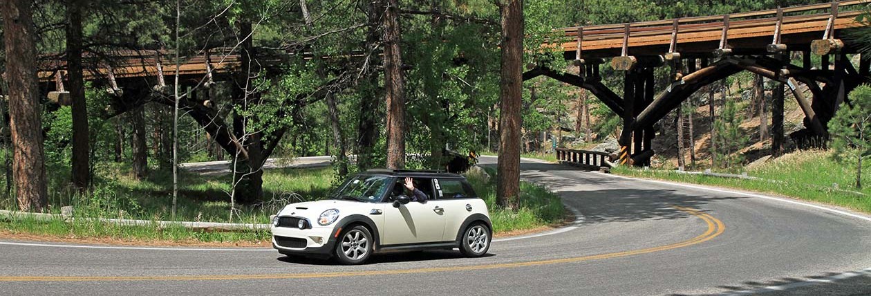
On the way out of Kingman, we took some time to photograph some of the buildings and signs. Then we found our way to historic Route 66 known as Oatman Road west of Kingman. Oatman Road continued west over the Black Mountains. Along the way, the variety of cacti changed from the east side to the west side. And the road, well, it was a Mini road! We stopped on the way up the mountain at a local establishment called Cool Springs Cabins where we met and talked with the proprietor while we obtained a couple of Pepsi’s and a post card before continuing on our way. We got some good advice and learned that the trip over to Oatman was 8 miles and included 122 curves/switchbacks over Sitgraves Pass.

Top speed–20 mph with some places marked 15 and a few at 10 mph. A great ride!
Oatman, AZ is famous for its free roaming burros. We saw 8 or 10 and photographed a few. Otherwise, the town is mostly a tourist mecca. Moving on to, the next place on our list was Needles, CA. We photographed some saw tooth shaped mountains and the “Welcome to California” sign as we crossed the Colorado River.

There was a noticeable difference in the arid climate between Oatman and Needles–much drier and the vegetation changed again. Different cacti!
In Needles, we took a few photos and took an alternative route through town on a second pass following the instructions from our maps. If doing it again, I’d say these few blocks don’t add any value to the trip. On the way out of town, we had some trouble finding the route and took CA-95 N heading toward Nevada. We figured it out after 8 miles and turned around to get back on the route. When we got back to the correct turnoff, it was marked going south, but there was no sign on the north bound side.
This put us in the direction of Chamblis and Amboy. This was where Joyce had staked out a geocaching expedition in the Mohave Desert. It’s a special kind of cache called geoart. From the map, there were a lot of geocaches 0.1 mile apart that formed the US highway shield, two “6” figures and the letters RT at the top. Just like the signs. There was no thought of doing all of these, but we did about 24 in about 2-1/2 hours. Walking around the Mohave Desert between 1:30 and 4:00 PM was a hot experience! We had plenty of water, food in case we got lost, walking sticks and a GPSr. We found all but one on the circular part of one “6” but didn’t want to continue to finish the 6 because of time in the sun and heat.
Gary in the desert!

The Mohave Desert….
![]()
Oh, yeah, speaking of heat, here’s how the day went:
9:30 AM 90 degrees
11:30 AM 101 degrees
12:00 N 102 degrees
12:30 PM 104 degrees
12:40 PM 105 degrees
12:56 PM 107 degrees
01:00 PM 108 degrees
01:10 PM 106 degrees
04:45 PM 113 degrees
05:30 PM 107 degrees
We had 5-60 air conditioning until about 12:30 when we turned the A/C on for the rest of the day.
While walking around in the Mohave, we lost site of the car for most of the time. It would be easy to get totally lost within about 0.25 miles. On the way back after finding the last cache, I kept thinking what if we can’t find the car (failed to mark it’s location on the GPSr when we started out) or it went missing. Fortunately, the first cache we found was within sight of the car.
I also found that I could “smell” the heat because the air was different and the arid climate changed the ability to smell. It was probably 113 to 114 during our caching experience. Saw a few lizards, a jackrabbit and very little else. The vegetation was also limited. We had a good time and drank all the water doing this.
After the cache, we had a cold beer in the car while the A/C ran to cool off the car. Plus a few crackers for sustenance to get us to Roy’s Café in Amboy, CA. We found a cache at Roy’s and had a Route 66 Rootbeer each before continuing on our way to Twentynine Palms, CA where planned to spend a couple of nights and see Joshua Tree National Park before returning to the historic Route 66 drive.
Arrived in Twentynine Palms about 5:30 and checked in to the Best Western, unloaded the car and sat back to soak up some cool while watching the news, Wheel and Jeopardy. Maybe the pool will be next!
No pictures of the desert rats though!
Yes, it’s only 60 miles from Santa Fe to Albuquerque, but it took us nearly all day to get there. We left at SF 8 AM and arrived ABQ at 3:30-ish!
But there was a side trip a couple a few miles out of SF called the La Bajada. Of course, it had a cache. Only thing is we had to walk up hill to get it. It was located on a really old section of the historic route 66 that is today only passable via high clearance 4-wheel drive vehicles. Lots of curves, big rocks and wash outs. However, we did see two such vehicles making the trek during hour hike up to get the cache which took us about an hour to get to the top. It was 1.67 miles. Only 37 minutes to return to the car. Gravity works better going down!
As we neared ABQ Joyce wanted to see the Petraglyph National Monument. So, we stopped and spent about an hour walking on the Boca Negra trail which, you guessed it, was mostly up. We saw quite a few of the petraglypys on the rocks for hundreds to thousands of years old made by the ancient Pueblo people who inhabited the Rio Grande river valley.
Arriving at our hotel, another Best Western, we decided the weather might be better tonight for taking the Sandia Peak Tram up to the top in hopes of getting great pictures and a nice dinner. We hurried out of the hotel and up the road to get there in time to take the 5 PM tram to the top for our dinner reservations at the High Finance Restaurant. Yep, high finance alright! As usual we shared an entrée and both were too full for dessert.
We stayed on top until just after sunset taking the tram back down.
Although there was a geocache located in the parking lot, we didn’t find it. Then followed the Garmin nuvi back to the hotel by some different route than we got there.
Tomorrow, depending on the weather is ABQ day.
Finally, some photos from the first two days of the Route 66 Adventure! These are all from my phone camera, but most photos are on the “big camera” and take more time to get from camera to web! These will have to do for now.


To view the contents of this post, you must be authenticated and have the required access level.
To view the contents of this post, you must be authenticated and have the required access level.
Still working on the details for the trip. Gathering items to make a more complete first aid kit–just in case! Need to get the Murano into the shop for one last makeover before departure.
Gary ordered and received “The Map Series” by Jerry McClanahan and Jim Ross in early May. There are 8 maps-one for each state on the Route. I used these to plan the trip generally–how many days, what to see along the way, etc.
You must be logged in to post a comment.